SolveItClass 9 · NCERT

NCERT Solutions · Class 9 Social Science Shaping of the Earth’s Surface

30 questions · 30 still being checked

Let's Explore 2.1–2.8 (part 2 of 6)

  1. Exercise 2.1

    Examine the plate map (Fig. 2.3\displaystyle 2.3) with the earthquake and volcano map (Fig. 2.4\displaystyle 2.4). What correlation do you observe?NCERT_Question_Class9_SocialScience_Ch2_LE_Q2-1-2NCERT_Question_Class9_SocialScience_Ch2_LE_Q2-1

    The book prints no answer for this

    NCERT publishes no answers for this textbook, so there is nothing in the book to check this working against. It has also not yet been read through by hand.

    The earthquakes and volcanoes on Fig. $\displaystyle 2.4$ sit almost exactly on the plate boundaries drawn on Fig. $\displaystyle 2.3$ — the two maps match line for line.
    Very few of them appear in the middle of a plate; the interiors are mostly quiet.
    The thickest belt of both runs right around the Pacific plate — this ring is the Ring of Fire.
    The reason is that boundaries are where plates collide, pull apart, or slide past each other, so the crust cracks, shakes, and lets magma escape.
  2. Exercise 2.2

    Observe the map showing the distribution of earthquakes and volcanoes (Fig. 2.4\displaystyle 2.4). Can you identify which continents and countries are located around the Ring of Fire with the help of an atlas or a globe?NCERT_Question_Class9_SocialScience_Ch2_LE_Q2-2

    The book prints no answer for this

    NCERT publishes no answers for this textbook, so there is nothing in the book to check this working against. It has also not yet been read through by hand.

    What the task asks for
    Use an atlas or globe with Fig. $\displaystyle 2.4$ to name the continents and countries that ring the Pacific Ocean, where the Ring of Fire lies.
    Worked example (an example of the shape of the answer)
    Start by tracing the outline of the Pacific Ocean in your atlas — the Ring of Fire follows its edge.
    Continents touching that edge: Asia and Australia on the western side, North America and South America on the eastern side, and Antarctica at the southern end.
    Then list countries along the same line, for example Japan, Indonesia and the Philippines on the west, and Chile, Peru, the United States of America and Canada on the east.
    A good answer must contain
    Continents first, then countries, worked anticlockwise or clockwise around the ocean so nothing is missed.
    The chapter's reason written underneath: these places lie along plate boundaries of the Pacific plate, which is why earthquakes and volcanoes cluster there.
  3. Exercise 2.3

    Does India have a risk of earthquakes? India has experienced some major earthquakes in the past, resulting in thousands of deaths. A large earthquake in a densely populated country like India can cause severe damage to life and environment. Can you find out which region is more vulnerable to earthquakes? Why do you think human lives are at risk?

    The book prints no answer for this

    NCERT publishes no answers for this textbook, so there is nothing in the book to check this working against. It has also not yet been read through by hand.

    Does India have a risk of earthquakes?NCERT_Solution_Class9_SocialScience_Ch2_LE_Q2-3
    Yes. The chapter states that India has experienced some major earthquakes in the past, resulting in thousands of deaths.
    Its example is the $\displaystyle 2001$ earthquake in Gujarat, which caused extensive damage.
    Which region is more vulnerable?
    The Himalayan belt is the region to look at first. The chapter explains that the Himalaya is a fold mountain range made where continental plates collide — and collision boundaries are exactly where earthquakes occur.
    Gujarat, in the west, has also suffered a major earthquake, as the chapter's photograph shows.
    The chapter does not print a map of India's earthquake zones, so find one in an atlas and mark the zones yourself before writing your final list.
    Why are human lives at risk?
    India is densely populated, so one earthquake reaches very many people at once.
    The chapter notes that a large earthquake in such a country can cause severe damage to life and environment.
    Buildings, roads and bridges collapse, and the damage cuts off help from reaching the survivors.
  4. Exercise 2.4

    Look carefully at this photograph and answer the following questions: → What do you think caused this situation? → What could that grey powder be? → What does it tell us about the Earth’s internal forces?NCERT_Question_Class9_SocialScience_Ch2_LE_Q2-4

    The book prints no answer for this

    NCERT publishes no answers for this textbook, so there is nothing in the book to check this working against. It has also not yet been read through by hand.

    What do you think caused this situation?NCERT_Solution_Class9_SocialScience_Ch2_LE_Q2-4
    A volcanic eruption. The chapter's caption for this photograph says it shows the deposition by volcanic eruption.
    Everything in sight is buried under material thrown out by the volcano.
    What could that grey powder be?
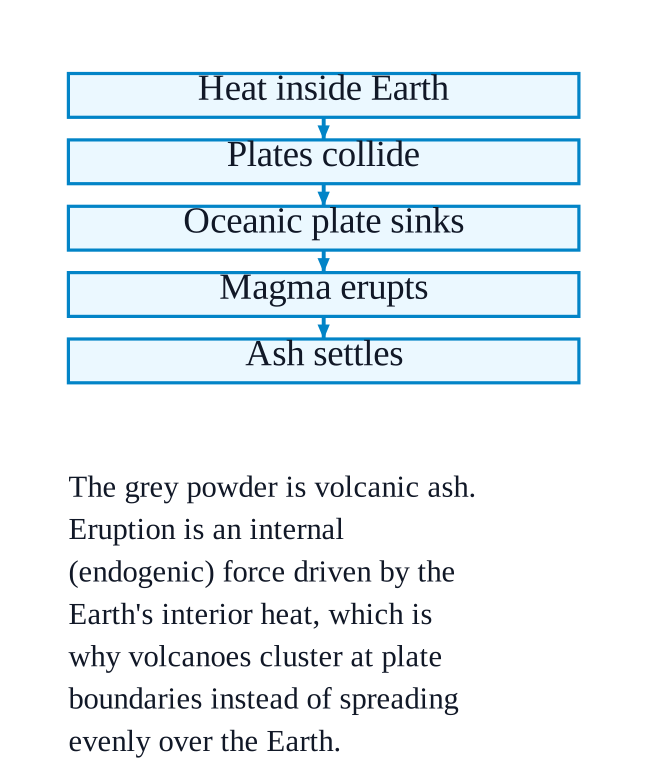
    It is volcanic ash — the fine grey material thrown into the air during an eruption and settled over the ground.
    What does it tell us about the Earth's internal forces?
    It shows that the Earth is hot and molten inside, and that this material can reach the surface.
    Volcanic eruptions are an internal (endogenic) force, driven by heat from the Earth's core and by the movement of tectonic plates.
    Such eruptions happen mainly at plate boundaries — for example where an oceanic plate sinks beneath a continental plate — which is why volcanoes are not scattered evenly over the Earth.
  5. Exercise 2.5

    Observe the photographs (Fig. 2.9\displaystyle 2.9) and also note the types of erosion. How are farmers affected by erosion due to water and wind?NCERT_Question_Class9_SocialScience_Ch2_LE_Q2-5

    The book prints no answer for this

    NCERT publishes no answers for this textbook, so there is nothing in the book to check this working against. It has also not yet been read through by hand.

    The two types of erosion in the photographsNCERT_Solution_Class9_SocialScience_Ch2_LE_Q2-5
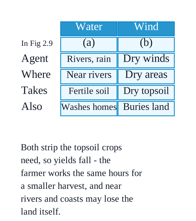
    Fig. $\displaystyle 2.9$ (a) shows water erosion — caused by rivers, rain or ocean waves.
    Fig. $\displaystyle 2.9$ (b) shows wind erosion — common in dry and sandy areas.
    How farmers are affected
    Erosion removes the fertile topsoil that crops need, so yields fall.
    Water erosion also washes away land, houses and roads for those farming near rivers and coasts, causing damage and loss of property.
    Wind erosion strips loose, dry soil from open fields in dry regions and can bury them under blown sand.
    Together these losses hit farmers' labour and livelihoods, not just their land — a farmer works the same hours for a smaller harvest.
  6. Exercise 2.6

    Have you heard about the Sundarbans delta? Try and explore its uniqueness and find out why it is popular with tourists.NCERT_Question_Class9_SocialScience_Ch2_LE_Q2-6

    The book prints no answer for this

    NCERT publishes no answers for this textbook, so there is nothing in the book to check this working against. It has also not yet been read through by hand.

    What the task asks forNCERT_Solution_Class9_SocialScience_Ch2_LE_Q2-6
    Find out, from an atlas or library book, what makes the Sundarbans delta special and why tourists go there — then write it in your own words.
    Worked example (build it from what the chapter says about deltas)
    Say where it is and how it formed: a delta forms at the mouth of a river, where the river meets the sea and drops the sediment it has carried from upstream, building a fan-shaped or triangular piece of land.
    Say what the land is like: delta soil is rich alluvial soil, so deltas are highly fertile and grow crops such as rice and jute.
    Say what the water is like: in a delta, fresh water mixes with salt water, and that mixture supports diverse aquatic life — good for fishing, and interesting for visitors.
    Say what tourists come to see, from your source, and name the source.
    Add the risk the chapter mentions: deltas are prone to flooding, which affects human life and activities.
    A good answer must contain
    One line on how a delta is formed, in your own words.
    At least two features found from your source, with the book or website named.
    One line on why people visit, and one line on a danger or problem the delta faces.
  7. Exercise 2.7

    Observe the landforms around your school or residence and try to identify which agent may have created them.

    The book prints no answer for this

    NCERT publishes no answers for this textbook, so there is nothing in the book to check this working against. It has also not yet been read through by hand.

    What the task asks for
    Look at the land around your own school or home, and work out which agent of gradation shaped what you can see.
    Worked example (an example — yours will depend on where you live)
    Near a river: a winding bend with a steep outer bank and a sandy bar on the inside is a meander, made by running water.
    On a coast: a sandy shore, a steep rock face rising from the sea, or a pillar of rock standing offshore are a beach, a sea cliff and a sea stack — made by waves and currents.
    In a dry, sandy area: a ridge or hill of sand is a dune, and a polished or streamlined rock is a ventifact or yardang — made by wind.
    In a high mountain area: a broad valley with a U-shaped cross-section, or a ridge of loose rock and debris left at a glacier's edge, is the work of glaciers.
    In limestone country: a cave, a hollow with dripstone inside, or a sudden pit in the ground (a sinkhole) is the work of underground water.
    A good answer must contain
    At least two landforms you have actually seen, each named.
    The agent for each one, with a reason — the clue in its shape that made you decide.
    A sketch or photograph of one of them, labelled.
  8. Exercise 2.8

    Complete the exercises given at the end of each type of disaster with the help of newspapers, atlases, and books. Make a list of disaster-prone areas from India and the world and enlist mitigation measures quoting recent examples.

    The book prints no answer for this

    NCERT publishes no answers for this textbook, so there is nothing in the book to check this working against. It has also not yet been read through by hand.

    What the task asks for
    Fill in the three blank lines — Prone areas, Mitigation measures, Recent examples — printed under each of the four disasters (landslides, avalanches, GLOFs, dust storms), using newspapers, atlases and books.
    Worked example (landslides — the shape to follow for all four)
    Prone areas: steep hill slopes with loose or weathered rock, especially where there is heavy and continuous rainfall. Name the specific hill districts you find in your atlas.
    Mitigation measures: stop the human causes the chapter lists — deforestation, mining, road cutting and unplanned construction on hillsides — and fix poor drainage, since accumulating water is what makes slopes fail. Hold the slope with terracing and bunds.
    Recent examples: give the place, month and year from the newspaper report you used, and name the newspaper.
    A good answer must contain
    All four boxes filled, each with its own causes taken from the chapter — snow instability and sudden warming for avalanches; glacier melt, heavy rain and dam collapse for GLOFs; drought, loose dry soil and sparse vegetation for dust storms.
    A combined list of prone areas, split into India and the world.
    Every example dated and sourced, never written from memory.