SolveItClass 9 · NCERT

NCERT Solutions · Class 9 Social Science Shaping of the Earth’s Surface

30 questions · 30 still being checked

Questions and activities 2.11–2.15 (part 6 of 6)

  1. Exercise 2.11

    Prepare a map showing landform-associated disasters that happened in the current calendar year.

    The book prints no answer for this

    NCERT publishes no answers for this textbook, so there is nothing in the book to check this working against. It has also not yet been read through by hand.

    What the task asks for
    Draw an outline map and mark on it the landform-associated disasters that have occurred during this calendar year, found from newspapers.
    Worked example (the method — the events must be this year's, from your own reading)
    Choose the area: an outline map of India, or of the world if your teacher asks for both.
    Fix your list of disaster types first, taken from the chapter — landslides, avalanches, GLOFs, dust storms, and you may add earthquakes and volcanic eruptions.
    Make a key: one symbol and colour per type, for example a brown triangle for a landslide, a white triangle for an avalanche, a blue drop for a GLOF, a yellow swirl for a dust storm.
    Collect the events: read the newspaper each day for a week, or search a library archive. For each event note place, district, state, date and source.
    Mark them: put the symbol at the right place on the map and number it. Below the map, write the numbered list with dates and the newspaper each came from.
    Add one line of pattern: for example, whether the landslides cluster in hill regions and the dust storms in dry regions — which is what the chapter would lead you to expect.
    A good answer must contain
    A key and a title with the year, since the map is only true for that year.
    Every event dated and sourced. Never mark an event from memory.
    A short note underneath saying which landform each type of disaster belongs to.
  2. Exercise 2.12

    Create a poster showing landforms that are considered to be sacred or important in your region, and add the folk stories associated with them.

    The book prints no answer for this

    NCERT publishes no answers for this textbook, so there is nothing in the book to check this working against. It has also not yet been read through by hand.

    What the task asks for
    A poster showing the landforms in your own region that people treat as sacred or important, with the folk stories attached to them.
    Worked example (an example of the shape — your landforms will be local ones)
    Pick three or four landforms, each of a different kind, so the poster shows variety: a hill or peak, a river bend or waterfall, a cave, a spring or a rock.
    For each one, put four things on the poster: a drawing or photograph; its name; the agent that made it (running water, glacier, wind, waves or underground water); and the story or custom in two or three sentences.
    Example of one entry: a waterfall — drawn as a river dropping over a cliff, formed where hard rock resists erosion while the softer rock below is worn away; the chapter notes that waterfalls often hold cultural or religious significance in certain regions; then the local story, written as told to you.
    Say who told you: 'as told by …, of … village'. This keeps a folk story honest — it is someone's telling, not a fact.
    A good answer must contain
    Landforms that are really in your region, named.
    The geographical explanation beside the story, so the poster teaches both.
    The source of each story — an elder, a book, or a temple record — written next to it.
    A title and a neat layout, since it is meant to be displayed.
  3. Exercise 2.13

    Document a case of a disaster that hit your region in the past, highlighting its effects on various human activities.

    The book prints no answer for this

    NCERT publishes no answers for this textbook, so there is nothing in the book to check this working against. It has also not yet been read through by hand.

    What the task asks forNCERT_Solution_Class9_SocialScience_Ch2_QA_Q2-13
    Write up one real disaster that struck your region in the past, and show what it did to the different things people do for a living.
    Worked example (the shape of the write-up)
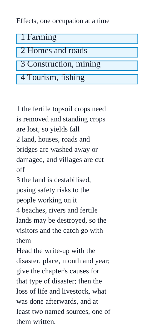
    Heading: the disaster, the place, and the month and year.
    What happened: three or four sentences, taken from your sources.
    Why it happened: the causes from the chapter for that type of disaster — for a landslide, heavy and continuous rainfall, steep slopes, loose rock, deforestation, mining, road construction and poor drainage.
    Effects on human activities, taken one occupation at a time, the way the chapter's model does it: farming (topsoil and crops lost, yields fall), housing and transport (land, houses, roads and bridges damaged, villages cut off), construction and mining (land destabilised, safety risk), tourism and fishing (beaches, rivers and fertile land damaged).
    Effects on life: people and livestock lost, and how long recovery took.
    What was done afterwards: relief, rebuilding, and any measure taken to stop it happening again.
    Sources: newspapers, an interview with an elder who remembers it, or a district record — each named and dated.
    A good answer must contain
    A real, dated event, never an imagined one.
    Effects split by occupation, not one lump paragraph.
    At least two sources, one of them written.
    One line on what your region should do differently next time.
  4. Exercise 2.14

    Translate the given poster on landslide into your native language and display it in your home.

    The book prints no answer for this

    NCERT publishes no answers for this textbook, so there is nothing in the book to check this working against. It has also not yet been read through by hand.

    Doing the translation
    Start by copying the landslide poster printed with this question, line by line, on to a rough sheet — in the order the poster itself puts them — so that nothing is missed later.
    Read the whole poster once before translating anything, so you know what the message as a whole is warning about.
    Translate the meaning, not word by word; a word-by-word rendering of a warning usually reads awkwardly and is skipped by the reader.
    Fix one word for each key term before you begin — decide what you will call a landslide, a slope, heavy rainfall, debris — and use that same word every single time it appears. Switching words midway makes a safety message confusing.
    Keep each line short and in the command form. A poster is read in a hurry from a few steps away.
    If your language has no everyday word for a term, keep the English word and put your explanation in brackets beside it.
    Copy every number, place name and date exactly as the poster prints it, if the poster carries any. Numbers are never translated or rounded.
    Keep whatever headings, order and layout the poster uses; add nothing of your own and leave nothing out, so that the translated poster carries the same warning as the original and no extra one.
    Get it checked by an adult who speaks the language well, then write the final copy in large, clear letters with a thick sketch pen.
    A worked example of the method
    The sample line below is an example written here to show the method — it is not a line copied from the poster in the book.
    Sample English line: "Heavy rain can loosen a hillside — move away from steep slopes."
    Example rendering in Hindi: "भारी वर्षा से पहाड़ी ढीली हो सकती है — खड़ी ढाल से दूर हट जाएँ।"
    What was decided while doing it: the term for landslide was fixed once and reused, the sentence stayed short and in the command form, and no warning was added that the original line did not carry.
    Displaying it at home
    Put it where the family passes daily — beside the main door, or where everyone gathers — at eye level, not above a cupboard.
    Read it aloud once to the family, so that even those who cannot read get the message.
    The point of the whole activity is this: a landslide warning saves lives only if the people around you can read it in their own language.
    Check before you put it up
    Every line of the original appears, in the original's own order.
    One fixed word for each term, all the way through.
    Any numbers or place names copied exactly.
    Letters big enough to be read from a few steps away.
    Someone who speaks only your native language can read it out and say correctly what to do.
  5. Exercise 2.15

    Divide the class into three groups. Each group will work on one project (water, wind, and glacier). The project should highlight the causes, impact on human life and the environment, and mitigation measures.

    The book prints no answer for this

    NCERT publishes no answers for this textbook, so there is nothing in the book to check this working against. It has also not yet been read through by hand.

    What the task asks forNCERT_Solution_Class9_SocialScience_Ch2_QA_Q2-15
    The class splits into three groups — water, wind, glacier — and each group presents its agent's causes, impact on human life and the environment, and mitigation measures.
    Worked example (the water group; the other two follow the same three headings)
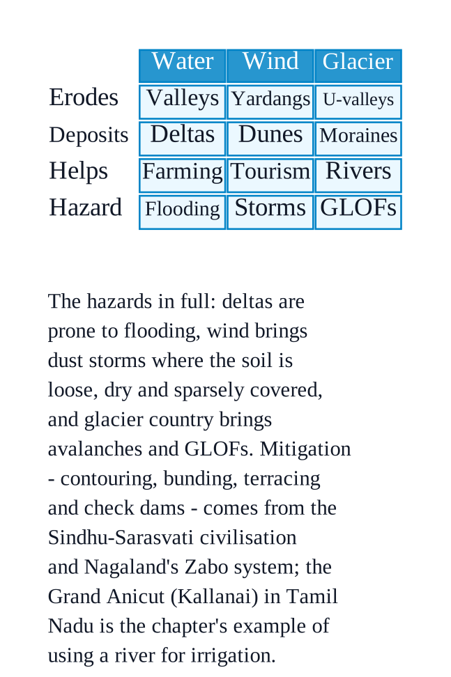
    Causes and the landforms made: running water erodes, transports and deposits. In the upper course it makes V-shaped valleys, waterfalls and rapids; in the middle course it meanders and makes oxbow lakes and floodplains; in the lower course it deposits deltas, levees and alluvial fans.
    Impact on human life: fertile soil along meanders and in deltas supports farming, including rice and jute; settlements grow on the gentle slopes near meanders; rivers give navigation, irrigation and tourism; waterfalls give hydroelectric power. The Grand Anicut, also known as Kallanai in Tamil Nadu, is the chapter's example of using a river for irrigation.
    Impact on the environment: deltas mix fresh and saltwater and support diverse aquatic life; but water erosion strips fertile topsoil and washes away land.
    Mitigation measures: contouring, bunding, terracing and check dams to slow run-off and hold soil — the methods the chapter traces to the Sindhu-Sarasvatī civilisation and the Zabo system of Nagaland.
    What the wind group must cover
    Landforms: yardangs, ventifacts, deflation hollows or blowouts, desert pavements, and dunes (barchan, longitudinal, star, parabolic).
    Impact: dunes act as natural barriers against desertification and wind erosion, protect coastal settlements from sea winds and waves, supply sand for construction, and attract tourism; the disaster is the dust storm, caused by drought, loose dry soil and sparse vegetation.
    What the glacier group must cover
    Landforms: U-shaped valleys, cirques, aretes, hanging valleys, fjords, and moraines (lateral, terminal, medial) built of till.
    Impact: trekking, skiing and mountaineering; fjords used as harbours and for fishing; fertile glacial soil; and glaciers as a crucial source of fresh water feeding rivers downstream. The disasters are avalanches and GLOFs.
    A good answer must contain
    The same three headings for all three groups, so the presentations can be compared.
    Every landform named with the process that made it — erosion or deposition.
    At least one Indian example per group.
    Mitigation measures that match the causes the group has just described.