SolveItClass 9 · NCERT

NCERT Solutions · Class 9 Social Science Shaping of the Earth’s Surface

30 questions · 30 still being checked

Questions and activities 2.1–2.10 (part 5 of 6)

  1. Exercise 2.1

    What are the sources of energy that are required to cause movements associated with the internal forces of the Earth?

    The book prints no answer for this

    NCERT publishes no answers for this textbook, so there is nothing in the book to check this working against. It has also not yet been read through by hand.

    The energy is heat from inside the Earth, mostly from its extremely hot core.
    NCERT_Solution_Class9_SocialScience_Ch2_QA_Q2-1
    This heat makes molten material in the mantle rise; cooler material sinks back down.
    That rising and sinking sets up convection currents, which push and pull the tectonic plates and make them move a few centimetres a year.
    Because the asthenosphere below the plates is semi-molten, the plates are able to slide on it.
    The chapter shows this interior heat travelling by three mechanisms — advection, convection and conduction — with the crust, upper mantle, lower mantle and outer core each contributing a share of the total interior heat flow ($\displaystyle 24$%, $\displaystyle 22$%, $\displaystyle 32$% and $\displaystyle 22$%).
  2. Exercise 2.2

    Relate various physiographic divisions you have studied in the earlier grades with various endogenic forces responsible for their origin.

    The book prints no answer for this

    NCERT publishes no answers for this textbook, so there is nothing in the book to check this working against. It has also not yet been read through by hand.

    Note before you begin
    Endogenic forces are the internal forces — the ones acting from inside the Earth: plate movement, folding, faulting, earthquakes and volcanic activity.
    The one division this chapter settles
    The Himalaya is a fold mountain range. The chapter states that when continental plates collide at a convergent boundary, they form fold mountains such as the Himalaya. So the mountain division of northern India owes its origin to plate collision.
    The endogenic forces available to you for the other divisions
    Convergent boundary, oceanic plate meeting continental plate: the oceanic plate sinks beneath the continental one, giving volcanic activity and earthquakes.
    Divergent boundary: plates move apart, magma rises and forms new crust, building mid-ocean ridges such as the Mid-Atlantic Ridge.
    Transform boundary: plates slide past each other without making or destroying crust, mainly causing earthquakes — as along the San Andreas Fault.
    Folding and faulting, which the chapter's summary lists among the internal forces that create mountains, valleys and ocean basins.
    How to finish the answer
    Take the list of physiographic divisions from your earlier grades, write each one down, and against it write which of the forces above could have raised it.
    Be honest where you are not sure: divisions built by deposition, such as the great river plains, are the work of external forces, not endogenic ones.
  3. Exercise 2.3

    Why and where do earthquakes occur frequently? Is it possible to predict earthquakes?

    The book prints no answer for this

    NCERT publishes no answers for this textbook, so there is nothing in the book to check this working against. It has also not yet been read through by hand.

    Where earthquakes occur frequentlyNCERT_Solution_Class9_SocialScience_Ch2_QA_Q2-3
    Along plate boundaries — the edges where two tectonic plates meet. Very few occur in the middle of a plate.
    Especially around the Pacific Ocean, in the belt known as the Ring of Fire.
    At transform boundaries, where plates slide past each other — the chapter's example is the San Andreas Fault in the United States.
    At convergent boundaries, where an oceanic plate sinks beneath a continental plate, giving both volcanic activity and earthquakes.
    Why they occur there
    The lithosphere is broken into plates that keep moving over the semi-molten asthenosphere, driven by convection currents in the mantle.
    Where two moving plates meet, they collide, pull apart, or grind past one another, and the crust shakes.
    Can earthquakes be predicted?
    The chapter does not claim they can. What it says is that plate tectonics is very important for the identification of earthquake- and volcano-prone regions and for managing the disasters that follow.
    So we can say fairly well where an earthquake is likely, but the chapter gives no method for saying when.
    It does record an early attempt: in the Bṛihatsaṁhitā, Varāhamihira devoted a section to earthquakes, noting how changes in wind, rain, clouds, animal behaviour and planetary alignments could signal them, and attributing them to four elemental forces — Vāyu (wind), Agni (fire), Indra (heaven/thunder) and Varuṇa (water).
  4. Exercise 2.4

    “Plate movements are responsible for the distribution of earthquakes and volcanoes.” Explain.

    The book prints no answer for this

    NCERT publishes no answers for this textbook, so there is nothing in the book to check this working against. It has also not yet been read through by hand.

    The statement is correct: most earthquakes and volcanoes occur along plate boundaries, and hardly any in plate interiors.
    Convergent boundaries — plates moving towards each other
    Two colliding continental plates crumple upward into fold mountains such as the Himalaya, and the collision shakes the crust.
    Where an oceanic plate meets a continental plate, the oceanic plate sinks beneath it, leading to volcanic activity and earthquakes.
    Divergent boundaries — plates moving apart
    Magma rises from below into the gap and forms new crust, creating features such as mid-ocean ridges — the Mid-Atlantic Ridge is a good example. Volcanic activity therefore follows these lines too.
    Transform boundaries — plates sliding past each other
    No crust is created or destroyed, so there are no volcanoes here, but the grinding causes earthquakes — for example along the San Andreas Fault.
    The proof on the map
    Comparing the plate map with the map of earthquakes and volcanoes shows the two patterns lying on top of each other.
    The clearest case is the Ring of Fire around the Pacific Ocean, which is simply the boundary of the Pacific plate.
  5. Exercise 2.5

    Draw and label a diagram of a meander and a delta.

    The book prints no answer for this

    NCERT publishes no answers for this textbook, so there is nothing in the book to check this working against. It has also not yet been read through by hand.

    What the task asks for
    Two labelled drawings in your notebook: a meander and a delta. Draw them yourself — copy the shapes from Fig. $\displaystyle 2.11$ and Fig. $\displaystyle 2.12$ in the chapter.
    How to draw the meander, and what to label
    Draw a river as two roughly parallel wavy lines making large loops across a flat plain.
    On the outside of a bend the water cuts into the bank: draw it sharp and label it Steep Bank (this is where lateral erosion happens).
    On the inside of the same bend the river drops sediment: draw a small crescent of sand and label it Bar (this is deposition).
    Draw one loop that has been cut off from the river and left as a curved pool of water beside it. Label it Oxbow lake.
    Label the channel itself River, and add an arrow showing the direction of flow.
    How to draw the delta, and what to label
    Draw one river coming down the page and label it River.
    Where it nears the sea, split it into several smaller channels spreading out like an open hand. Label these Distributary.
    Draw the land between the channels as a fan-shaped or triangular patch, with small patches of land between the channels labelled Islands/Bars.
    Shade the water the river empties into and label it Sea.
    A good answer must contain
    All four labels for each diagram, exactly as the chapter's figures give them.
    A title under each drawing, and a one-line note saying a meander forms in the middle or lower course of a river while a delta forms at its mouth.
  6. Exercise 2.6

    How are deforestation and erosion associated with each other? Explain.

    The book prints no answer for this

    NCERT publishes no answers for this textbook, so there is nothing in the book to check this working against. It has also not yet been read through by hand.

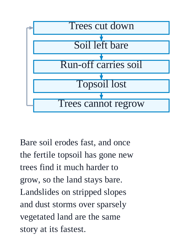
    They are linked because plant cover is what protects soil from erosion — remove the plants and erosion speeds up.
    NCERT_Solution_Class9_SocialScience_Ch2_QA_Q2-6How deforestation leads to erosion
    Cutting down trees leaves the soil bare and exposed to rain, running water and wind.
    The chapter makes this point directly for dust storms: sparse vegetation cover, often due to deforestation, overgrazing or poor farming practices, leaves the land exposed so that strong winds can lift the loose, dry soil.
    On slopes, deforestation is listed among the human activities that disturb the natural balance of slopes, along with mining, road construction and unplanned building — and unstable slopes fail as landslides, which is erosion at its fastest.
    Water that once soaked in now runs off the bare surface, so more soil is carried away.
    Why it matters
    Erosion removes the fertile topsoil that crops need, so yields fall.
    It washes away land, houses and roads near rivers and coasts, and destabilises land for construction and mining.
    The link the other way
    Erosion also makes the loss of forest worse: once the topsoil has gone, new trees find it much harder to grow back, so the land stays bare. This is why the two are treated together.
  7. Exercise 2.7

    Develop a plan to protect the land in your local area from erosion.

    The book prints no answer for this

    NCERT publishes no answers for this textbook, so there is nothing in the book to check this working against. It has also not yet been read through by hand.

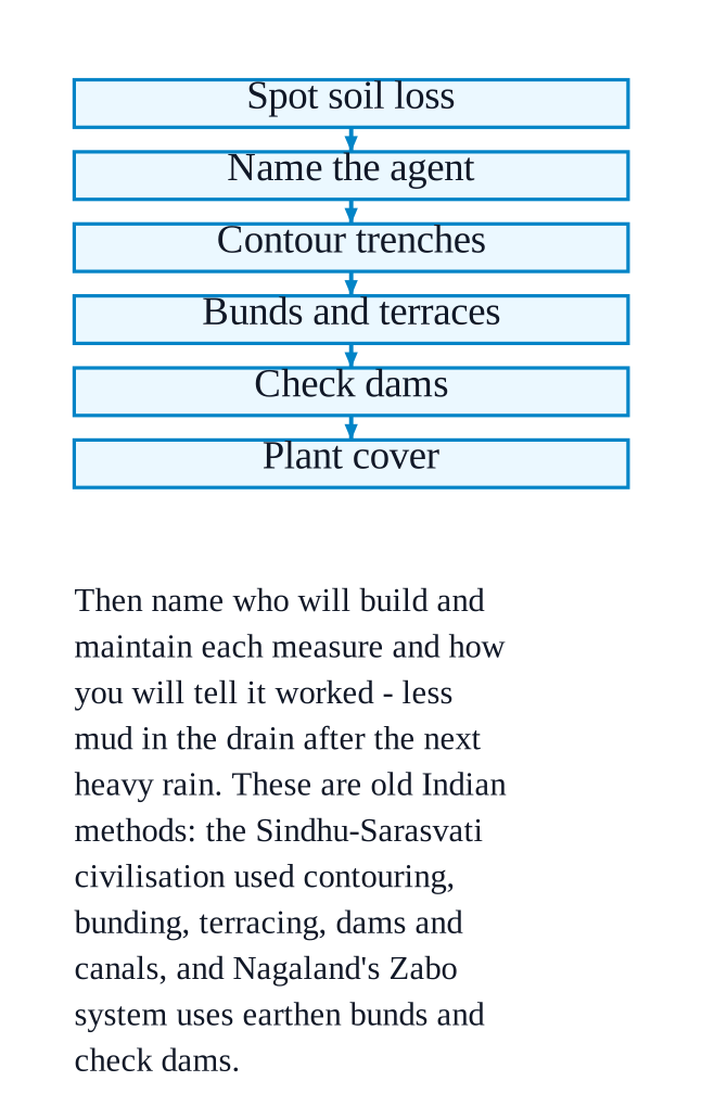
    What the task asks forNCERT_Solution_Class9_SocialScience_Ch2_QA_Q2-7
    Write a practical plan for stopping soil being carried away in your own locality, using methods from the chapter.
    Worked example (an example plan — yours must fit your own area)
    Step $\displaystyle 1$ — find the problem: walk around and note where soil is being lost. Look for bare slopes, gullies cut by rainwater, and open sandy patches where the wind blows the surface away.
    Step $\displaystyle 2$ — name the agent: decide whether it is water erosion or wind erosion, because the treatment differs.
    Step $\displaystyle 3$ — for a slope, use the chapter's methods: dig a continuous contour trench along the contour lines of the hillside to slow, hold and soak in rainwater; build bunds, earthen embankments along contour lines, to slow surface run-off; and cut terraces, a series of level or gently sloping steps, so the water never gains speed.
    Step $\displaystyle 4$ — for a stream: build check dams across small streams to reduce water velocity, prevent soil erosion and let sediment settle, as was done in the Zabo system.
    Step $\displaystyle 5$ — for wind: plant and protect vegetation, since the chapter says bare, sparsely vegetated land is what lets wind lift the soil.
    Step $\displaystyle 6$ — who does what: name who will build and maintain each measure, and when you will check it.
    A good answer must contain
    At least one problem seen in your own area, described in one line.
    Two or three measures named from the chapter, each matched to the problem it solves.
    Who will do the work, and how you will tell whether it worked — for example, less mud in the drain after the next heavy rain.
    Something to mention
    These are old Indian methods, not new ones. The chapter records that the Sindhu-Sarasvatī civilisation used contouring, bunding, terracing, dams and canals, that the practices are documented in the Vedas, Kṛiṣhiparāśhara, Kauṭilya's Arthaśhāstra and Vṛikṣhāyurveda, and that the Zabo system of Nagaland uses earthen bunds on hillslopes for soil and water conservation.
  8. Exercise 2.8

    Which disasters do you think you might experience in your region? Discuss a mitigation plan in your classroom.

    The book prints no answer for this

    NCERT publishes no answers for this textbook, so there is nothing in the book to check this working against. It has also not yet been read through by hand.

    What the task asks for
    Work out which of the chapter's disasters could actually strike where you live, then agree a mitigation plan for it as a class.
    Worked example (an example — the answer changes with where your school is)
    Match your landform to the disaster: hill slopes → landslides; high snow-covered mountains → avalanches; a valley downstream of a glacial lake → GLOFs; a dry or semi-arid, sandy region → dust storms; a region near a plate boundary → earthquakes.
    Give the reason from the chapter: for a hill town you would write that heavy and continuous rainfall seeps into soil and rock, increasing weight and reducing friction, and that steep slopes with loose or weathered rock make it worse.
    Then write the plan in three parts:
    Before — stop the human causes the chapter names (deforestation, mining, unplanned hillside construction, poor drainage); build bunds and terraces; keep an emergency kit and a list of phone numbers.
    During — an agreed warning signal, a safe assembly point, and one route to it that does not cross the danger slope.
    After — a head count, first aid, and how the village or ward reports damage and asks for help.
    A good answer must contain
    The disaster named, with the landform that makes your area prone to it.
    Its causes taken from the chapter, not invented.
    A plan split into before, during and after, saying who does each thing.
    One recent example from a newspaper, with its date and source.
  9. Exercise 2.9

    Prepare a model of landforms created by underground water.

    The book prints no answer for this

    NCERT publishes no answers for this textbook, so there is nothing in the book to check this working against. It has also not yet been read through by hand.

    What the task asks forNCERT_Solution_Class9_SocialScience_Ch2_QA_Q2-9
    Build a physical model — clay, plaster, thermocol or waste material — of the landforms that underground water makes.
    Worked example (one way to build it)
    Choose the setting: underground water makes these landforms in areas of limestone or other soluble rocks, by chemical weathering and erosion. The whole set of landforms is called Karst topography — write that on your label card.
    Make the block: shape a rectangular block of clay to stand for a hill of limestone, and cut it open at the front so the inside can be seen.
    Hollow out a cave: scoop a hollow space inside the block. That is a cave, formed as acidic water dissolves the rock. Leave an opening at the front for the cave mouth.
    Add the dripstone: hang thin cones from the roof of the cave for stalactites, and stand matching cones on the floor for stalagmites. Where one pair has joined top to bottom, label it a pillar.
    Add a sinkhole: press a round depression into the top surface where the ground has collapsed into a cavity below, and label it sinkhole (doline).
    Add an underground river: run a blue thread or painted channel through the cave floor and out of the hillside, labelled underground river.
    A good answer must contain
    All five landforms — cave, stalactite, stalagmite, sinkhole, underground river — each with a label card.
    A one-line note on the rock type and the process: soluble rock, dissolved by acidic water.
    A short note on why these matter to people: they supply fresh water, attract tourists, and some hold cultural or religious significance.
  10. Exercise 2.10

    What precautionary measures will you take if you are staying in an earthquake-prone region?

    The book prints no answer for this

    NCERT publishes no answers for this textbook, so there is nothing in the book to check this working against. It has also not yet been read through by hand.

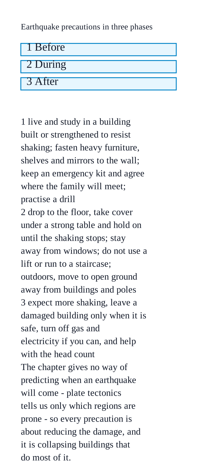
    The idea behind every precautionNCERT_Solution_Class9_SocialScience_Ch2_QA_Q2-10
    You cannot stop an earthquake, and the chapter gives no way of predicting when one will come — so all the precautions are about reducing the damage when it does.
    The chapter's point is that plate tectonics lets us identify earthquake-prone regions in advance, and that risk to life is high because India is densely populated, with severe damage to life and environment.
    Before an earthquake
    Live and study in a building that has been built or strengthened to resist shaking, since the chapter's photograph of the $\displaystyle 2001$ Gujarat earthquake shows that it is collapsing buildings that cause the damage.
    Fasten heavy furniture, shelves and mirrors to the wall so they cannot fall on anyone.
    Keep an emergency kit — water, torch, whistle, first-aid box, important papers — and agree where the family will meet.
    Learn the safe spots in each room and practise a drill at home and at school.
    During an earthquake
    Drop to the floor, take cover under a strong table, and hold on until the shaking stops.
    Stay away from windows, and do not run to a staircase or use a lift.
    If you are outdoors, move to open ground away from buildings, walls and electric poles.
    After an earthquake
    Expect more shaking, and leave a damaged building only when it is safe to move.
    Turn off gas and electricity if you can, and help with the head count.